
Falkner Traverse
Clickee para versión en Español
During December 1st to 3rd, 2016, we walked with Seba and Fer one more of those long traverses with a taste to dream: To join the ends of Falkner mountain range and Mesa peak, from Ruta 40 all the way to Filo Hua Hum camping — not by the lake shore, but… around the summits of course!
These were three whole days of walking; both long and full of experiences; as well as short, which ended quickly making us wish we enjoyed them more. I am trying to share this experience as condensed as possible. For those who bore quickly, you can always just scroll through the pictures.
Previous Days
The traverse lasted three days. But the adventure starts months earlier (or years) and keeps lasting as I write this telling. Planning the route, forming and disbanding the group who would come. The date, the working and vacations days. Deciding the meals, the shopping, who brings what. The transports. The technical equipment we could or could not use. Will there be hard snow? Will there be water at all? Shall we need to climb, or rapell?
The date comes with the bitter news of a friends’ farewell, a known mountaineer from our community – someone I have been following in the trails (maybe decades later). Also right in another anniversary of my dad’s goodbye, who comes with me every step.
Weather forecast threatened with storms and changed every day. The day prior to departing it was giving the exact window of three good days; breaking into storms on the fourth (a backup day we might need to use). Lickily, this forecast was accurate… and seeing the storm through a window, back at home the next day after coming back, was relieving.
Day 1
After a night of no sleep, as usual before an adventure, we start at 7am when Jere picks us up to takes us near Pichi Traful where we know a trail starts. At 8:45 we are already walking up, zigzagging to find the real trail and adjusting and readjusting our backpacks so our bodies get used to the considerable weight we are carrying.
The South face trail is steep from the beginning, in the forest. More than we recalled. Our memory easily forgets those boring or painfulparts from the trails. This is not only steep but blocked by big trees fallen in last and past seasons, that we need to pass over — or crawl under. Something not trivial when your backpack seems to weigh as much as yourself.

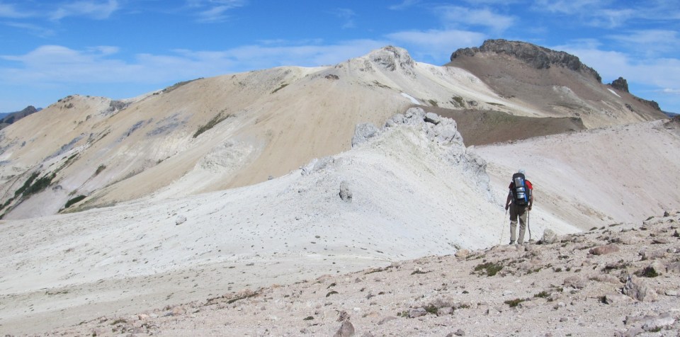
Just after 11am we leave the achaparrado to some high plains in south face, where it really takes dimension (a big one) how harsh is this first day in terms of meters to climb. The Falkner-Alto (I called it this way as some call it Alto (Spanish: “high”), but maps locate the Alto further East, in our second day) appears still far, and most importantly, high. In the picture, the yellow-orange section is our known pass to the north face.

We rest a bit in the shadow and start wearing sunscreen, which will accumulate in coats as paint in the next days. The body thanks the change of slope we start to get closer to the edge that will takes up to the Falkner-Alto peak.

The day is windy but clear; beautiful to walk at this altitude. We see all summits in the side of Traful lake, as well as the western ones more remarkable as the Peñascoso and Crespo, appealing in any picture…

In the big bowl before South edge we fill water, knowing we will likely not see more than snow until our camp. Also and by a friend’s request, we pile big rocks: he should be here with us but could not come, and asked for references to come later this year. (Enjoy it – I will not return!)

Once in the edge we progress in a traverse keeping altituted heading North, and then the real climb to the mountain pass. The first part goes quickly thanks to some hard snow covering all loose rocks underneath.

The second part is much, much harder. The sedimentary deposit is…. like any other. And there is no other way than going up through it. We start getting further from each other according to one’s rythm and, when I try, we cannot even shout at each other as the wind does not let me hear my own voice. In the picture, Seba and Fer come from far down the rocks, as a pack of clouds appears to chase them as race cars.

When reaching the pass the landscape changes. There is more snow and, mainly, we stop climbing that much to start walking forward. Behind a big rock we have some quick lunch as we can, and leave just as quickly as the wind is cooling us fast (and it is not time or place to start wearing a big down jacket; my own pride would prevent me from using it now).

So we leave quickly, though at easy pace. I start to fully enjoy this mountain. From this ridge all terrain is new to me, although I have been close to here other times. Now we are over Falkner lake and see all familiar summits North, direction of home. And these peaks are full of unique rock castles.

We climb around one of those castles, which just this season lost one of its towers — which is spread all over this year’s snow. It is curious that I feel amazed at a bunch or rocks, but I cannot stop thinking we are witnessing something proving that none of these mountains is totally still, static. These details, I think, are things very few people have the opportunity to watch; and even fewer to really observe. (In the picture, we see the gray stripe diagonally over the snow.)

After traversing a last ridge we get closer to the real obstacle of the day; one that we do not know for certain how to cross and which could bring us back home or down to the lake if not succeeding. The summit in next picture is surrounded by walls (right, South) and steep terrain not safe to cross either on the North (left). Our best options are doing the summit (uncertain on how to unclimb it behind) or crossing the couloir we had seen in satellite imagery, which appeared with snow this day.

Lucikly given the time of the day (and the season), only a few meters of snow are left, hard enough to mark big steps and soft enough to feel safe even without using our piolets or rope. In fact, all technical equipment was carried in our backs the three days, untouched.

Past this obstacle I am not feeling cold anymore, thanks to the adrenaline generated. We use that push to continue walking the last meters till our proposed Camp 1: a huge bowl, almost perfectly circular, which I found no way to fit in a single picture…

At this time some strong wind gusts are blowing, and though we walk every corner and rock there is no good refugee from it for our bivouacs.

The “best” idea (in terms of originality at least) is to dig about one feet of snow left next to a wall which reasonably stopped the wind. We cut and pulled big ice bricks with our piolets; remove them and plan to use them as kind of igloo walls. This was fun, entertaining… up to the point we realize the soil left is a mix of ice and melted snow, and the sand underneath is saturated with water — the most humid place to sleep.

At least we warmed up during the exercise. And used the piolets for something! But we move a few meters and settle down on a shelf were the wind blows hard, but is at least flat and dry. With sun already behind the summit, the temperature goes down very quicly and we do not do much more than eating our bolognese pasta and enter our bags.

Clouds fly fast and lower every minute; the summits of Cerro Buque across the lake start to hide in clouds. We leave the packpacks half prepared for an eventual escape in the night, in case it rained, and just close our eyes. Even when the sky is visible between clouds, there is daylight so I do not see stars. My few attempts of watching stars in the night when I wake up are quickly cancelled by the wind throwing sand grains into my eyes.

Día 2
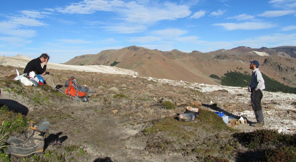
Next time I know is at 6am when Seba wakes us up while preparing mate. During the night the sky cleared, and the dawn is pristine and gives a whole new perspective to our day and to our adventure.

The cold froze the snow around, so I cannot even reach the water stream flowing between them — too early to slip and get hurt! We start pretty cold but soon after climbing a few meters the sunlight starts warming us and, adding a descent we do on loose rocks to avoid some potentially dangerous summits, we end up in t-shirts in less than an hour.

The walk continues easy as we lost altitude and the terrain is softer. We still walk among rocky towers, many of them probably unclimbed.

Wherever you look there is a picture. Everything calls my attention, and my camera’s. Even the same places, from you perspectives, are worth a picture…. here, we spot the Chapelco Grande just behind the Buque.

As we travel around the north side of this mountain and start turning right, the view opens to let us view, at the distance, the end of Filo Hua Hum lake, our final destination.

In the morning light, with lakes totally still, we have this unique view of lakes Falkner, Nuevo and Filo Hua Hum. I guess this gives the name to the property below – “Three Lakes”.

We let the deer guide us, even if we are not seeing and are not going to see any deer in these heights. If you know how to search, the animal trails are always wise and make sense: in general they are the least-effort paths, or go through the best terrain, or pass through water sources on their way.
We end this turnaround and get to the pass called “Bebederos” by Seba… although there is barely a small not-too-clear water stream. We load water anymore (any bacteria is considered protein?) and start climbing towards the next peak. In the ridge we find some snow, leftover of big winter cornices, which is completely covered by a few inches of sand: the wind must be constant here, and still transporting volcanic ash from 2011 eruption and depositing it here. In the tip of this snow tongue, the quick melting of snow under the morning ice makes sand to go down constantly, as in a sand dune. Something the picture cannot show, yet another curious thing I captured.

We have lunch at the end of this climb. There is soft wind, it is pretty hot, and the sun hits strong. None wants to start walking again but there is still a long way to go, so after an hour of rest we go straigt to the last big peak of the day, Cerro Alto (not the one in the next picture).

Passing Cerro Alto (or avoiding it, we did not fully climb it) we got to a painful view… This was the mallín (flooded meadows) initially proposed as Camp 2, that we eventually moved to shorten what would be a too long third day. The “new” Camp 2 was still very, very far away crossing several ridges and peaks — behind Cerro Piedra Mora (the one with black crowns after the white ridges end, in the picture).

Worse, as we were no certain of water availability in that camp, we carried extra water from this point. So we took about extra 3kg each, over what we were already felt like a too heavy backpack.
The ridges to get to Camp 2 are very pretty… beyond what I can really appreciate being so tired. Rocks change color to color every a few hundred meters; there are whites, yellows, orange and even green. The views open up North and South into long valleys going to the bottom on lakes Falkner and Traful.
These are three very long hours carrying the water to our camp. As last gift, the last 30 min are traversing very loose rocks — they cannot be missed. Finally, we get past the peak of Piedra Mora.
Our campsite (or bivouac) is exposed to the wind, but almost flat. Really awesome. There is some snow higher up, which we did not even need to melt. Not being blocked from the West, the sun still shines for quite a while, allowing us to relax a bit after 11 hours of walk.
The wind still blows. My attempt to prepare guacamole with the ingredients I brought hidden to this camp is anything but guacamole. From the too-green avocado to lots of sand brought to the plate thanks to the wind. Of course, it was delicious anyway; as anything is with enough distance and altitude.
The last talk of the day is arguing about the clouds shapes: if they predict bad weather, if the storm comes tomorrow, where we run away if rain and snow come right tonight.

However weather stays very good, and at 2am I wake up to see an incredible Milky Way, perfectly aligned with my sleeping bag (luckily; I would not even take my head out of it). I brought binoculars just for this moment, which are waiting next to my sleeping bag. This is truly magical, to multiply the already thousands stars I can see at plain sight, everywhere I focus the lenses. This is one of those unique experiences only mountain bivouacs give; a millon stars hotel!
Day 3
After watching the stars I slept so well that when Seba wakes us up it is past 7 already, the sun shining on our sleeping bags. We have a really quick breakfast and in a few minutes we are up and walking.

The first thing to call my attention today and intrigues me for a good while is a very sweet fragrance, that I cannot explain. We are in the middle of a rocky ridge, without more vegatation other than some heavy grass. We move for a while until a moment while, climbing the next small peak, I discover the parfume coming from some tiny yellow flowers covering a good part of this slope. It is incredible the long distance this scent travels! It must have been the right time when the flowers open at the first sunlight. Speaking of unique experiences that only make sense to me…

The sweetness of those flowers end very soon, as we traverse the peak from the wrong side; again on loose rocks. At least, from this side we are able to see, already from the distance, our second campsite — recalling a very similar place in Cajon Negro back in our journey from 2013.

The next hour or two is the climb to Cerro Negro, the last big peak before getting to Cerro Mesa. Despite finding horse traces, this place still appears unexplored and remote to us.

From some high plains we can already see the last summits of our journey, that we have been planning and navigating with help of our maps.

In the next plains we possibly find the explanation to so many deer and mountain lion footprints found everywhere. Although the only (living) animal we so was a gray fox, there are some caves under a big black rock which make the perfect hideout for a mountain lion. And, there are very recent deer leftovers! We cannot know if the puma is inside or not, but this is the ideal shelter and we do not really want to give our backs to it…. The only one who dares to is Fer, which gives me the guarantee that he would be the first to be eaten if the mountain lion wakes up still hungry!

We are still several kilometers from our destination, but our general fatigue and some minor injuries makes us decide to change plans. Instead of going through the ridges the rest of the day, we unclimb a bit and continue finding animal trails near the forest, without gaining more altitude.

We cros two or three big mallines, quite big. Almost the end of the journey, we can look back and see far in the distance already the various summits of Falkner peak, that we cross the day before yesterday — already bluish from the distance.

There is still distance to cover and, mostly, altitude to lose. As soon as we properly orient looking at the lake and the ridges we knew go down to the camping, with the relative safety of seeing some trails going down, we just unclimb straight. Sadly, we get a bit lost in the forest and do several zigzags before really going down.

Finally and after other 11hrs of walk, we get to the lake. Barely with time to soak in the water to wash out some dust and ash, right before Ricardo comes to pick us up.
We come back very tired and dirty, with a huge number of images to process (not just digital ones), that do not fit in our heads. Just after 10 days I start writing this telling, reviving those moments and leaving the notes ready to keep doing it over and over as I come back to this material.
Bonus
If you read so far, I hope this visualization transports you to the images you already watched. You can change speed, pause and resume, move the viewpoint at any time!
And the map and stats, too:
Max elevation: 2082 m
Total climbing: 4150 m
Total time: 09:10:51
[…] me: I climbed a few of its peaks through different routes and different conditions (including the three-day traverse we did in 2016, also in this blog). But flying from it was something yet to be done. I do not know who proposed it in the first […]